
Climate Canary in the Arctic
Photo: Jake Threadgould / REVOLVE
Photo: Jake Threadgould / REVOLVE
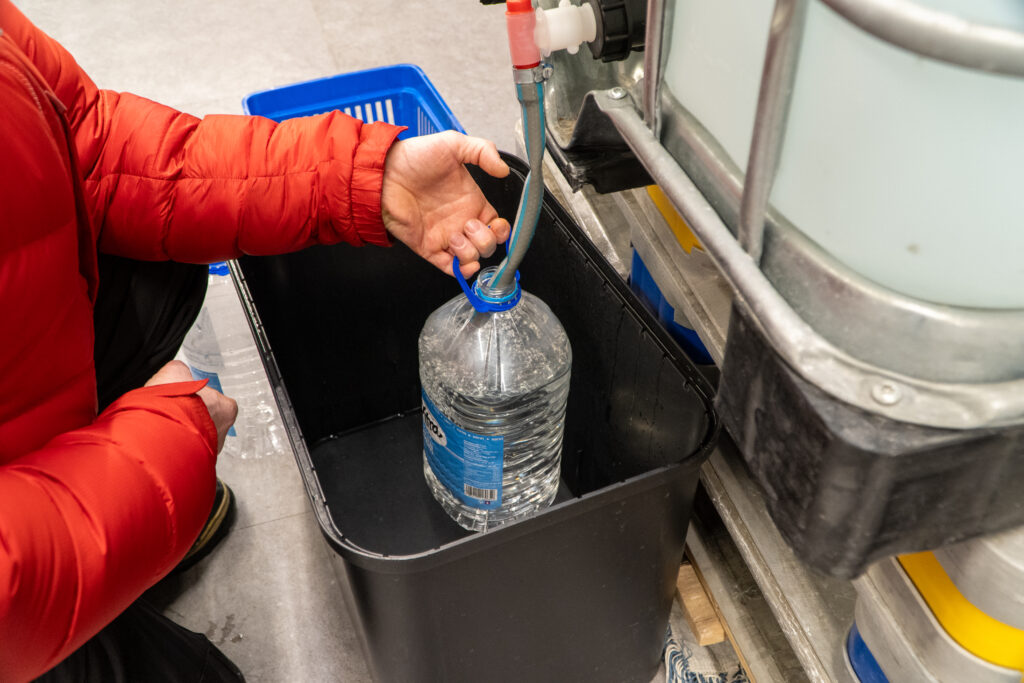
Inside the world’s northernmost supermarket, among the imported fruit and vegetables, a steady stream of people collect water from two large tanks – free of charge. Most customers come armed with 5-litre plastic bottles that they will then carry back to their homes in Longyearbyen, where the tap water is becoming too dangerous to drink.
This relatively minor inconvenience for residents of Svalbard is due to high levels of manganese in the local water supply, which scientists believe is being released by thawing permafrost and the emergence of new groundwater springs that percolate long-frozen material up to the surface.
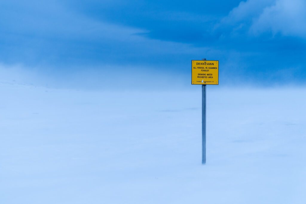
The water saga began in earnest in September 2025, when Svalbard’s authorities issued a general advisory against consuming tap water after they detected manganese levels as high as 1,000 micrograms per litre (µg/l), far above the World Health Organization’s recommended maximum rate of 80 µg/l.
Prolonged exposure to high levels of manganese can cause neurological disorders and is particularly dangerous for infants and children whose brains are in development. Tap water guidelines for youngsters were applied in Svalbard as early as February 2025.
The situation has prompted a blizzard of solution seeking. The water available at the supermarket comes from the Svalbard brewery (you guessed it, the world’s northernmost) as part of a deal with the local council.
The brewery’s output of purified water, which also goes to some of the bars and restaurants in Longyearbyen, is set to increase thanks to the delivery of a new reverse osmosis machine, freshly unveiled when REVOLVE visited the installations on 24 February 2026 (see: Brewing Change).
Far from being a local issue, the changes detected in the drinking water form part of a much larger picture of a rapidly shifting climate in the Arctic.
Svalbard is warming as much as seven times faster than the global average, according to numerous studies. Glaciers, which cover 57% of the archipelago, are retreating at dizzying speed, permafrost thaw is altering the landscape, and sea ice loss is affecting weather patterns.
The free water at the supermarket is merely a symptom of these unbridled shifts in climate.
To get a better understanding of these new interactions, scientists from the University Centre in Svalbard (UNIS) turned their attention underground. Rather fitting for a region that is steeped in coal mining history.
UNIS glaciology professor Andrew Hodson is at the wheel of the double-cabin belt wagon with post-doctoral researcher and permafrost expert Marjolaine Verret by his side. With a handful of visiting researchers and some state-of-the-art geophysics gizmos in tow, the diesel-powered wagon chugs up the Bolterdalen Valley towards the Scott Turnerbreen Glacier.
There is no asphalted road up to the field site, only some red poles marking out tracks for snowmobiles and dog sleds that haul tourists up to ice caves in the glacier. Strong winds have blown the snow into deceptively deep drifts, and the belt wagon gets stuck going over a ridge. Everyone piles out to dig a path through.
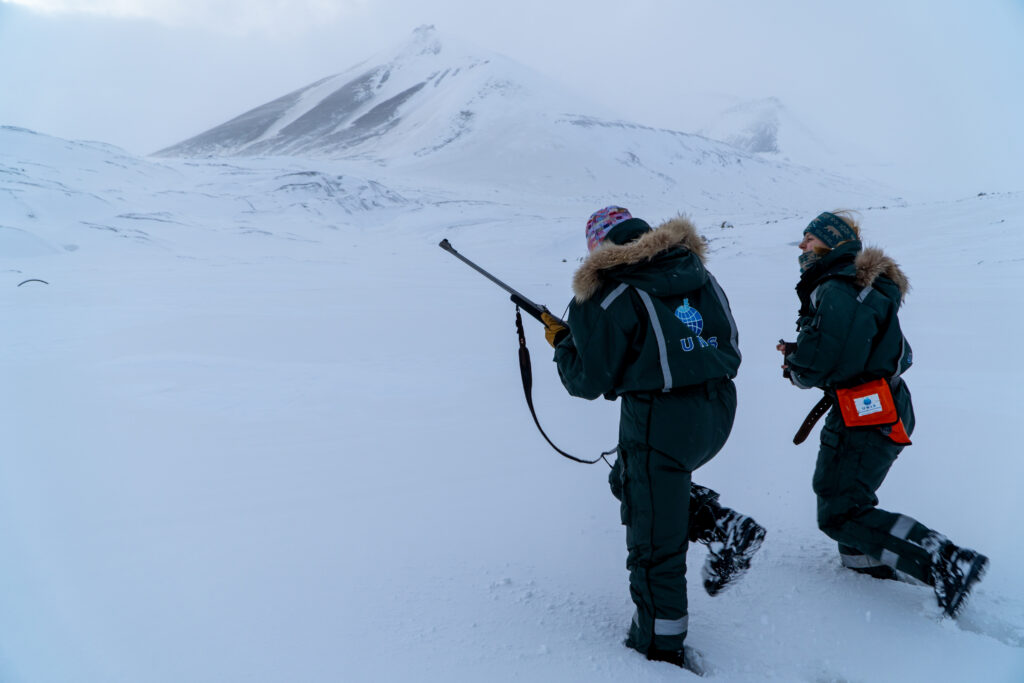
The group is armed with two rifles and a flare gun in case a polar bear turns up, an obligatory and diligently observed measure for anyone who travels outside the town Longyearbyen. You can bump into a polar bear anywhere in Svalbard, although the odds are low this high up in the valley.
The UNIS researchers are focused on the area of newly exposed land in the shadow of the Scott Turnerbreen Glacier, which is barely visible in the snow-covered valley. Here, they have set up a field observatory to collect data on the weather and to monitor permafrost formation and the emergence of water flows.
These studies are being carried out as part of the CryoSCOPE project, an EU initiative with Swiss and Indian involvement that is researching the cryosphere – the frozen parts of our globe – with case studies in the Himalayas, northern Scandinavia, Finland, the Alps, and Iceland.
Like many glaciers in Svalbard, Scott Turnerbreen is dwindling fast. According to Hodson, it has lost 90% of its volume in the last 100 years. It is precisely because of this rapid deglaciation that the UNIS scientists chose the site, as it offers unique insights into the changing interaction between the cryosphere, the atmosphere, and hydrology.
“We’ve just driven to Scott Turnerbreen through three moraine ridges, so we know there’s been quite a history of advances and now a major retreat,” Hodson says, referring to the rocky rubble lines that mark out the stages of a retreating glacier. “Some of those advances were climatically driven a few hundred years ago, at least one of them was due to a very harmful surge, a sudden unstable advance which was probably linked to warming around the turn of the last century.”
To the untrained eye, a glacier that has surged might appear to be large and healthy given its apparent reach down the valley. But that’s an illusion. In Svalbard, scientists think glaciers are surging due to warming temperatures and changes in the waterways below the glacier itself, which cause them to slip down the valley as they continue to melt.
“Scott Turnerbreen is quite interesting because it kind of tried to kill itself with one of these advances,” Hodson adds.
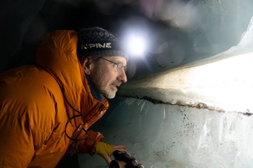
Professor Hodson guides REVOLVE into the belly of the glacier through a tight crawl space in the snow. Inside, the channel opens up into an ice cave carved out by flowing meltwater in the warmer summer months. Hodson can read the ribbed walls, gravel deposits, and trapped bubbles embedded in the meandering cavern like rings in a tree.
Cake layers of ice tell the story of freeze-thaw cycles over time. In the winter, the walls of the dormant river illuminate in frozen shades of blue, green, and white by the light of a head torch. Streaks of gravel and mineral deposits twinkle like jewels suspended in time.
These river paths, obscured by snow and ice on the surface of the glacier, are getting larger each year due to increased snow melt and meltwater from the retreating glacier.
“Every year it gets deeper and deeper, and it migrates in three dimensions, meandering and eventually cutting all the way to the bottom,” Hodson says, adding that the growing flows during the summer are “changing the way that water drains this landscape.”
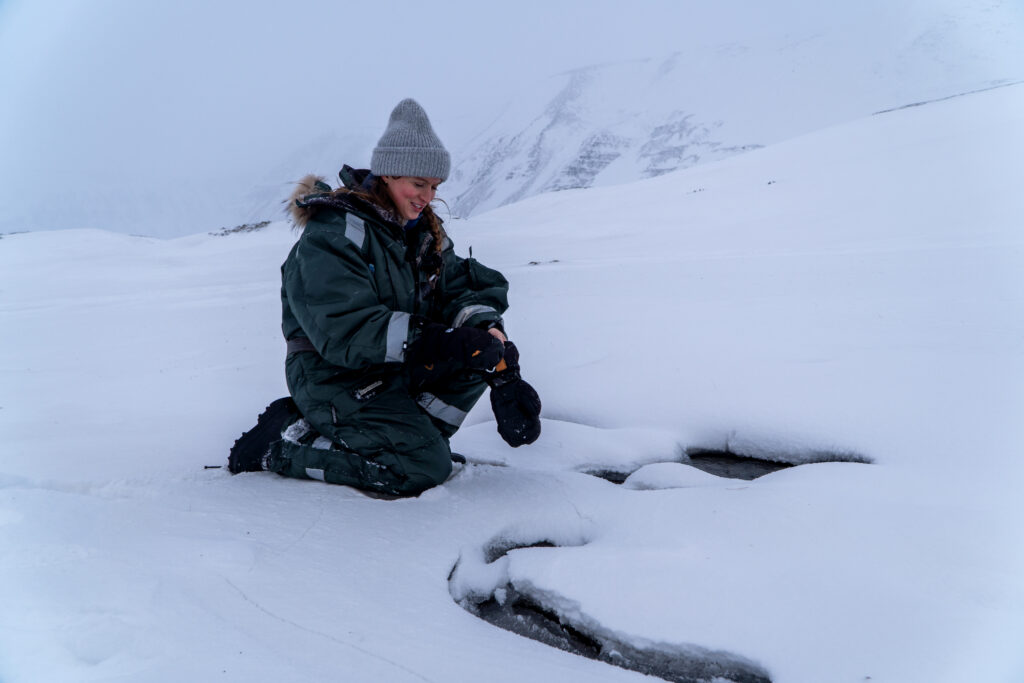
Back out on the glacial forefield, Marjolaine Verret, the permafrost expert, crouches down over two dark patches where the snow has been melted away by running water. This is unusual for late February in Svalbard, where temperatures the week prior dipped as low as –20C (-4F).
“You can actually see there’s liquid water right here in the middle of winter at -5C,” Verret tells REVOLVE. This water is not coming from inside the glacier, but rather from the ground below. What this tells Verret is that permafrost – ground that is frozen for two or more consecutive years – has not yet formed in this area of rapid deglaciation. This gives groundwater below an opportunity to punch through what would normally be impermeable ice, establishing a channel of liquid water that flows year-round.
“We don’t yet have permafrost closing the cryospheric cap at this location,” Verret says. “So, it (the groundwater) manages to emerge through these gravels into the forefield.”
The water that emerges at these springs brings with it a cocktail of minerals and metals including manganese, the same mineral that is contaminating Longyearbyen’s taps. It also brings up nutrients that are influencing change in the local ecosystems, Verret adds.
“These groundwaters are also rich in nitrates, which is basically what you find in farmland fertiliser. These nutrients are being used by opportunistic species like algae to colonise these waterways. It’s not all negative but it’s definitely a change to the environment.”
Permafrost is found under much of Svalbard, and ranges from around 100 to 500 metres deep, depending on where you probe. Seasonal thawing is creeping deeper into the ground each year at the expense of permafrost as temperatures rise.
Permafrost thaw and glacier melt lead to the release of large quantities of greenhouse gases like methane and carbon dioxide that were previously trapped beneath the ice. Most of this gas release is caused by permafrost thaw in places exposed by retreating glaciers, Hodson says. These greenhouse gas emissions are of global relevance as the onus of offsetting the consequences lies with policymakers further south.
“There’s an old adage that what happens in the Arctic doesn’t stay in the Arctic,” says Hodson. “It’s well known that warming here is having an effect in mid-latitude areas and it is proving costly.”
Snow and ice play a fundamental role in keeping the Arctic region cool by reflecting between 50-70% and 90% of incoming solar radiation, respectively. When sea ice, ice caps, glaciers, and snow melt over time, it increases the warming of the exposed sea and land, which warms the atmosphere and increases melting. This is known as ice-albedo feedback, a downward spiral of heating. This spiral of heating is known as ice-albedo feedback.
A visible example of this is the melting of sea ice, which in the Arctic has reduced by nearly 50% since 2000, according to the US National Oceanic and Atmospheric Administration.
This warming affects polar weather systems in a way that dominos down to southern latitudes, increasing the chances of frigid cold snaps and extreme weather like heavy rain.
“Our role in CryoSCOPE is not to catastrophise but quietly reveal these unstoppable changes that are happening here and make people realise that lifestyle adjustments are necessary,” Hodson tells REVOLVE. “Given what we are seeing here, we’re trying to get the message across to the relevant policy-making authorities that more multilateral action is needed.”
Back in Longyearbyen, the easing of the polar night heralds an influx of tourists. They come to get a taste of the Arctic, to see the alluring aurora borealis (northern lights), to pose with the polar bear signs, and often just to tick it off the bucket list.
The tourism industry has replaced coal mining as a major cog in the local economy. Old coal mining lodges have been converted into hotels and the town’s bars and restaurants are brimming with a medley of languages.
At this rate of climate change, Svalbard might have to start planning for a post-tourist future, too. The water collection points at the supermarket are here to stay for the time being, a minor but very real annoyance that is symptomatic of a rapid change afoot.
It’s cliché but undeniably fitting to call Svalbard a canary in a coal mine when it comes to climate. What is happening here is a warning to those of us who live further south. It is important that those in charge listen in, as the canary might be on its last few chirps.
Brewing Change
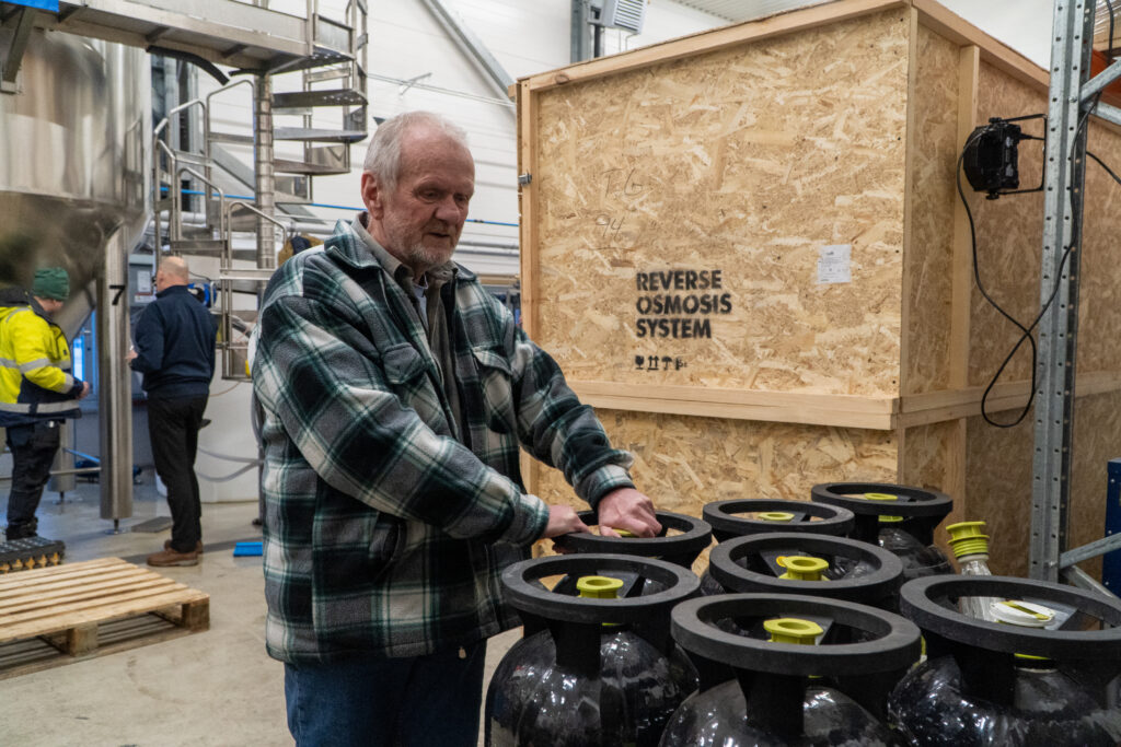
The Svalbard Bryggeri (“Svalbard Brewery”) is no longer just a purveyor of fine beer but has had to make extra room on the factory floor for a new reverse osmosis (RO) machine delivered in February 2026, which it will use to boost its production of purified drinking water for Longyearbyen residents.
The brewery has been providing the water available for free at the Svalbardbutikken department store since September 2025 as well as to some of the bars and restaurants in Longyearbyen, according to Bryggeri owner Robert Johansen. The cost of production is covered by the local council, which pays three krone (0.27 euros as of February 2026) per litre of water.
The brewery was already purifying water with ionised electrolysis as part of its beer production to remove manganese and sulphates as well as chlorine, which is used to kill bacteria like legionella that can live and propagate in Svalbard’s heated pipe system.
Johansen, who came to Svalbard in the early 1980s to work in coal mine 3 (now home to the Arctic World Archive data bank), tells REVOLVE he wouldn’t feel comfortable trying to turn a profit for the provision of water.
“We’re not that kind of business,” he says.
This feature is based on a field trip for the CryoSCOPE project to Svalbard during the week of 23-27 February 2026.